The following history of world maps is a condensed version covering the period from the ancients until the sixteenth century. Scroll to the bottom of the page for a link to much more information on the history of world maps.
The First Maps
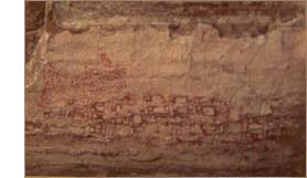
It is widely believed that cartography existed long before written language. The earliest “map” could possibly be a wall painting found in Ankara, Turkey, in 1963 by anthropologist James Mellaart. During the excavation of the ancient city of Catal Hyuk, Mellaart discovered this wall map that carbon-dated to about 6000 B.C. It is nine feet long and believed to be a map of Catal Hyuk itself, showing the town plan consisting of 80 buildings. The next oldest map is a clay tablet unearthed in 1930 at the ruins of Ga-Sur at Nuzi, in present-day Iraq. This specimen is about three inches square and depicts an area surrounded by hills and divided by a river or canal. It is drawn with cuneiform characters and stylized symbols scratched in the clay and inscriptions name some places and features. Conflicting opinions date the Ga-Sur tablet at either 2500 B.C. or 3800 B.C.
The first attempt at a world map is attributed to the Babylonians in the sixth century, B.C. It is a clay tablet on which the Earth is shown as a flat circular disk surrounded by ocean and several mythical islands. Stories indicate the Greeks inscribed maps on bronze tablets, but because none actually exist, we can’t be sure. Ancient Greek historian Herodotus recorded stories that suggest that the practice of a map drawn to scale was not familiar to the Greeks in the fifth century, B.C. However, a hint of cartographic advancement was indicated when Herodotus wrote of the arrangement of places relative to parallels and meridians.
Return to World Maps Home
Early Advances
The ancient Chinese appeared to be relatively advanced in their mapmaking. In the Hunan Province, two silk maps were found in the tomb of a prime minister’s son and date to the second century B.C. The maps are quite accurate and detailed, and as an indication of their sophistication, have standardized symbols and legends. Provinces are printed within squares and cities and villages in circles. Also remarkable is the fact that they are topographic, as they show rivers, mountain ranges and the South China Sea.
A major figure in the history of world maps was second century A.D. geographer Ptolemy. He was ahead of his time in the belief that the world is round, but he also believed the sun revolved around the Earth. Despite a few major errors in his theories, Ptolemy made some significant contributions to cartography. Also being a mathematician, he devised an easier way deal with the mathematics of a circle. Previously, a circle was divided into the awkward units of fractions. Ptolemy took the degree and subdivided it into what is known in Latin as partes minutae primea and partes minutae secundae. It is from those terms we get minutes and seconds. He also was the first to address the concept of projecting the sphere of the Earth on a flat surface.
Medieval and Renaissance
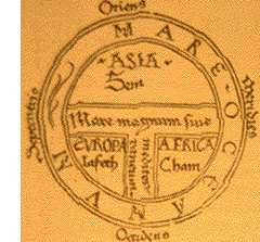
Religion played a part in the history of world maps. Much medieval cartography reflected Christians’ beliefs. The style was symbolic and ornamental and had little geographic value. Around the ninth century, A.D., the maps now known as T-O maps appeared. Their name comes from the configuration: a circular shape with the ocean at its edge (the O). The three known continents (Asia, Africa, and Europe) within were separated by two rivers and the Mediterranean, forming the T.
With sea travel becoming more widespread in the early fourteenth century, men known as cosmographers may have been the first to undertake mapmaking as a commercial interest. The cosmographers gleaned information from the sailors and their written accounts of coastlines, trade routes, and ports. From single-sheet charts, the cosmographers developed atlases containing as many as a dozen maps. The charts started out depicting the Mediterranean, then the coasts of Britain and Ireland, and then to the first charts showing Scandinavia as a peninsula.
Return to World Maps Home
The Early Globe
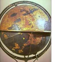
The Globe appears quite early in the history of world maps. Though the ancient Greeks are credited with the first globe, the earliest extant globe was made in 1490 by Martin Behaim of Germany. Behaim’s globe is just under two feet in diameter and has six colors and over 1000 place names. The equator is shown divided into 360 degrees and the ecliptic is labeled with the signs of the zodiac. Also present are the tropics and the Arctic and Antarctic circles. Christopher Columbus was a mapmaker and during his four voyages he charted numerous maps of the lands he saw.
Another Martin of Germany, Martin Waldseemuller, produced a woodcut-print map believed to be the first to show the new world named as the Americas. Dated 1507, the map shows North America as much too narrow, but South America is a little closer to reality. Ferdinand Magellan believed there was a strait at the southern tip of South America and postulated he could pass from the Atlantic to the Pacific, and eventually on to Asia. His journey ended with his death at the hands of the Phillipine natives, but the expedition continued on to Seville, finally proving that the Earth was indeed round.
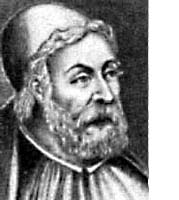
The Significance of Mercator
The history of world maps would not be complete without the mention of one of the most important people in cartography, Gerardus Mercator. He produced his first world map in 1538. Mercator’s primary contribution to mapmaking was a way to solve the problem of relatively accurately translating the sphere of the Earth to the flatness of a map. He drew the map with the lines of latitude having progressively greater spacing away from the equator toward the poles. To achieve his aim, he needed to make the meridians of longitude intersect the lines of latitude at right angles. This meant that as the lines of latitude grew further apart toward the poles, the meridians of longitude would need to be spread at the same proportion. The flaw in this method is that areas toward the poles are represented much larger than reality. Mercator partially solved his problem by showing the areas of the poles as insets on the maps. There are many different types of projections, and each has its problems. Though his projection seems less than ideal, Mercator’s system was a major advancement and is still in use today.
Click here for more information on the history of world maps.
Two sites with information on mapmakers are Louisiana State Museum and MapHist.com.
Return to World Maps Home