Introduction:
With the eTrex Legend, Garmin has loaded a full basemap of North and South America into one small unit. The Legend is also designed to provide precise GPS positioning using correction data obtained from the Wide Area Augmentation System (WAAS). This product will provide position accuracy to less than three meters when receiving WAAS corrections.
This place often has the best GPS prices…
What You Get:
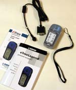
- The Garmin eTrex Legend GPS receiver
- lanyard
- owner�s manual
- quick-start guide
- PC data cable
Optional accessories:
- Carrying case
- Belt Clip
- Auto Power Adapter
- Data Cable (bare wires)
- Bicycle Mounting Kit
- PC Cable/Auto Power Adapter
- MapSource Map Data CD-ROMs
What It Does:
All of the information you need to operate the eTrex Legend can be found on five main pages (or display screens). You can press and release the Page button to cycle through the Satellite Page, Map Page, Navigation Page, Trip Computer, and Main Menu Page.
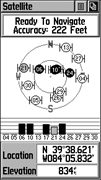
The Satellite Page shows satellite signal strength, displays when the unit is able to navigate, and tells the location by latitude/longitude. There is a �Skyview� graphic that shows the relative position of each satellite as if you were looking up at the sky. This display has each satellite’s assigned number labeled. Also shown here are bars indicating signal strength for each satellite. The strength of the signal is represented by the height of the bar.
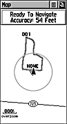
The Map Page displays your present position and direction of movement using a triangular �Position Icon� that is centered on the map. As you travel the map display leaves a �trail� (track log) of your movements. The map also displays geographic details such as major rivers, lakes, highways, and towns. A higher level of detail can be obtained by downloading maps from a CD ROM mapping program. The map scale can be changed from 20 feet to 500 miles.
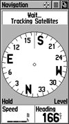
The Navigation Page provides active guidance with a rotating compass ring that shows your course over ground (track) while you�re moving and a bearing pointer to indicate the current direction to your destination (bearing) relative to the course over ground. The Status Window at the top of the page shows you the name of your destination, the distance, and the time to go. Two data fields are provided, and can be programmed to display a variety of navigation data. The �bent� (bearing) pointer arrow alerts you to the upcoming turn while you are navigating a route. When you get within 15 seconds ETA of the current point, the pointer �bends� to indicate the direction of the turn to the next point while still showing the direction to the current point.
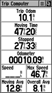
The Trip Computer Page displays up to eight different types of navigation data and are user programmable. Each data field is selectable and can contain one of many data information options. By selecting the information options that you prefer and arranging them in a desired order on the page, you can customize the Trip Computer Page to meet your navigation needs.
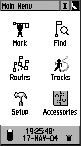
The Main Menu provides access to additional eTrex Legend feature pages. From the Main Menu Page you can mark and create new waypoints; find map items such as cities, interstate exits, addresses, points of interest, etc.; create routes; save tracks; setup system operating features; or access and use unit accessories.
Specifications:
Physical:
Case: Fully-gasketed, high-impact plastic alloy, waterproof to one meter for 30 minutes
Size: 4.4�H x 2�W x 1.2�D (11.2 x 5.1 x 3.0 cm)
Weight: Appr. 5.3 ounces (150 g) with batteries; 3.7 ounces (105 g) without batteries
Display Size: 2.1″H x 1.1″W (5.4 x 2.7 cm) backlit LCD
Antenna: Built-in patch
Temperature Range: 5 to 158 degrees F (-15 to 70 degrees C) (operating)
Performance:
Receiver: Differential-ready, 12 parallel channel
Acquisition time: Cold � appr. 45 seconds
Warm – appr. 15 seconds
First time – appr. 5 minutes
Update Rate: 1 second continuous
Position Accuracy: less than 15 meters (49 ft)
less than 3 meters, w/ WAAS
Navigation:
Waypoints: 1000 with name and graphic symbol
Routes: 20 reversible with up to 50 waypoints
Map datums: over 100
Tracks: 10; automatic track log
Position formats: 32
Power:
Input: Two 1.5 volt AA batteries
Battery Life: Up to 18 hours
Price:
Suggested Retail: $214.27
Mean Price Available on Internet: $224.92 USD
Practical Use:
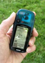
The eTrex Legend is quite small, but not as small as Garmin�s Gekos. The band of rubber around the edges of the unit give a good grip. The rubber-covered battery compartment door helps to resist sliding around on the dashboard or console when used in a vehicle. A bayonet-type latch makes access to the batteries easy.
My test unit took only 2 minutes and 30 seconds TTFF out of the box. Subsequent cold starts were about 45 seconds or less. During a 1.5 mile �neighborhood test walk,� the eTrex Legend had an estimated location accuracy of as little as 19 feet. Marking waypoints and naming them for selected locations was not as easy as the more basic units, but that is to be expected from a device that does as much as the Legend.
�Goto� is one of the most-used functions on a GPS receiver. After reaching the most distant point of my walk, and enabling �Goto,� the screen displayed the direction I needed to go to reach my starting point. I followed the direction indicated, and the distance remaining was within 10 feet of being accurate when I reached my starting point. The time to arrival is also displayed. The distance remaining is shown in miles down to one-tenth of a mile, then switches to feet.
Another useful function is the �TracBack.� On a separate test I walked to a certain point, then enabled the TracBack on the eTrex Legend. This allowed me to retrace my route back to the beginning. The compass arrow was quite accurate in guiding me to my starting point. A handy feature was the screen displaying �approaching turn� when I got close to the point where I needed to make a significant turn.
I wanted to use the route feature, so I plotted a route with Garmin�s MapSource software and downloaded the route to the eTrex Legend. I enabled �navigate� and followed the pointer on the compass face. The unit maintained an adequate signal on the console of my car. The pointer indicates the intended direction of travel and �bends� (it actually looks more like �broken�) when approaching a turn.
Testing under conditions of moderate foliage cover and next to 60-foot sheer cliffs showed that the eTrex Legend held its signal fairly well, and maintained a lock enough satellites to enable me to navigate.
The owner�s manual says �The eTrex Legend is designed to be held and operated in the left hand, but it can be held and operated using the right hand as well�� It can, of course, be operated in the right hand, but using the Click Stick obstructed the view of the screen. Another minor irritation was the use of the Click Stick. The Click Stick is a five-way switch (up, down, left, right, and press in). Occasionally, I would intend to push it up, down, left, or right and actually pressed it in (or vice-versa).
Cons and Pros:
Cons:
- Small screen size
- No barometric altimeter or electronic compass
Pros:
- Good TTFF
- Good retaining of fix
- Small size
Conclusion:
One advantage over the eTrex Summit is the Legend’s WAAS capability which means significantly improved accuracy. The calendar, mathematical calculator, and area calculator can actually be quite practical. The screen size is small, but it has a higher resolution than the less expensive half of the eTrex line, allowing more information to fit on the screen. I feel it’s priced right given what options it has. But why doesn’t Garmin include batteries?