April, 2004
by: J. Chartwell
Introduction:
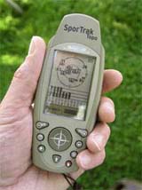
The Magellan SporTrak Topo has built-in nationwide (except for 20% of Alaska) topography, major roads, waterways, and more. It comes pre-loaded with just about everything needed to find your way in the backcountry. Hikers, hunters, freshwater fishermen, mountain bikers, and other outdoor adventurers find it very useful when navigating the backcountry of the U. S. (It’s available in the U. S. only). It’s a medium size and of moderate weight, and appears to be a rugged design. It has 108 MB of built-in, interactive, nationwide topographic maps. The SporTrak Topo is the only “grab-and-go” Topo GPS available, according to Magellan.
This place often has the best GPS prices…
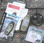
What You Get:
- SporTrak Topo GPS receiver
- MapSend Topo for the U. S. CD
- User manual
- 2 AA batteries
- Wrist strap
- PC cable
Optional accessories:
- Belt clip carrying case
- Swivel mounting bracket
- Vehicle mounting bracket
- Bicycle mounting bracket
- 12V external power cable
- External power/data cable w/bare wires
- External power/data cable
- MapSend Streets Europe CD
- MapSend Streets & Destinations in the U. S. CD
- MapSend Streets & Destinations Canada CD
- MapSend BlueNav CD Europe
- MapSend BlueNav CD North America
- MapSend Worldwide Basemap CD
What It Does:
The SporTrak Map has eight navigation screens: Map, Compass, Large Data, two Position screens, Road, Satellite Status, and a speedometer screen.
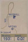
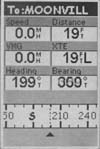
The Map screen has two modes, position or cursor. In the position mode, your present position is indicated by the large arrow icon in the center of the display. If you are moving, the arrow will point in the direction that you are heading. At the bottom of the screen is the scale for the map displayed and two data fields that can be customized, or turned off. In the Cursor mode, you are provided with a cursor that can be moved on the map. At the bottom of the display is the information for the position of the cursor relative to your present position. Any points of interest that the cursor is over will be shown.
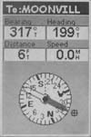
The Compass screen is customizable to display the information that is useful to you. The lower portion of the Compass screen not only displays your heading in a graphical manner, but also displays the relationship of the sun, moon and your destination to your heading.
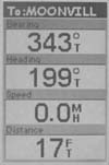
The Large Data screen is similar to the Compass screen but here the compass has been removed to allow for large display of the navigation data. This is ideal for when you need to use the receiver mounted on the dash of your car or boat. The display can be seen from a distance.
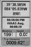
The Position screens 1 and 2 display your present position using the coordinate systems that you select. These screens show all of the basic position, time and satellite information. They also show the current navigation information at the bottom of the screen.
The Road screen presents your route as if you were traveling on a road. When you need to make a turn, the road will graphically display the turn and the direction. Waypoint and destination icons will be displayed relative to your position as they come into view. Above the road is a compass that displays your heading and above that are four customizable data fields.
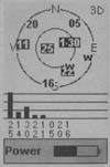
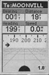
The Satellite Status screen provides you with a graphical display of the satellites in view and which ones are being used to compute the navigation data. The bar graph shows you the relative signal strength being received for each satellite. At the bottom of the display is an indication of the battery life remaining.
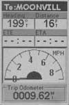
The Speedometer screen displays a graphic representation of a speedometer, similar to what is found in a car. The scale changes based on the speed of travel. For instance, while walking the upper end of the scale may be 6 MPH, while when driving on the expressway it may be 120 MPH. An odometer can be shown on the screen, as well as four customizable data fields.
When marking waypoints you can select its icon, name, and add a message. With the �Goto� feature you select a waypoint that was saved and the receiver guides you to that point. �Backtrack� allows you to retrace your steps back to your starting point.
Specifications:
Physical:
Case: Rubber Armored Impact Resistant Plastic waterproof to one meter for 30 minutes
Size: 5.6″H x 2.2″W x 1.2″D (142 x 56 x 30 mm)
Weight: 4.6 oz.(131 g) without batteries, 6.2 oz. (176g) with batteries
Display Size: 2.2″ x 1.4″ (56 x 36 mm)
Display Resolution: 160 x 104 pixels
Antenna: Quadrifilar Helix
Temperature Range: 14F to 140F (-10C to 60C), operating -4F to 158F (-20C to 70C), storage
Performance:
Receiver: 12 Parallel Channel, WAAS Enabled
Acquisition time: Cold � less than 2 minutes
Warm – less than 60 seconds
Hot – less than 15 seconds Update Rate: 1 second continuous
Position Accuracy: less than 7 meters, horizontal
less than 3 meters, w/ WAAS
10 meters, vertical
Navigation:
Waypoints: 500
Trackpoints: 2000
Routes: 20
Map datums: 76
Power:
Input: Two AA batteries
Battery Life: Up to 14 hours
Price:
Suggested Retail: $399.99
Mean Price Available on Internet: $305.84 USD
Practical Use:
The Magellan SporTrak Topo is a medium-sized receiver and has enough weight to give it a quality feel, but still not too heavy. The nine buttons on the face of the unit are easy to use. It is narrow, meaning most people can wrap their hands around it and use their thumb to access the buttons, allowing comfortable one-handed use. As with most devices that have a great variety of options, navigating through all the menus takes some getting used to.
Two minor inconveniences: Attaching the PC cable requires tedious manipulation to align the screw to its hole and twist a small “D” ring few times. Likewise, the battery compartment is accessed by turning another small “D” ring nine full turns. I found that holding the “D” ring and turning the receiver was easier.
The TTFF out of the box was a fairly quick 1 minute and 55 seconds. Subsequent cold starts were about 36 seconds. At walking speed, the estimated position error was usually about 30 – 40 feet unless it was receiving WAAS. According to the specs, WAAS accuracy is less than 3 meters (10 feet). Marking and naming waypoints was relatively simple and the SporTrak Topo offers 42 different icons to represent waypoints.
The �Goto� feature is fundamental to a GPS receiver. After reaching the most distant point of my walk, and enabling �Goto,� the screen displayed the direction I needed to go to reach my starting point. As I followed the indicated direction, the time to arrival and distance is also displayed. The distance is shown in miles down to one-tenth of a mile, then switches to feet. Upon arriving at my starting point, the distance remaining was off by about 90 feet, which is not as good as other models I’ve tested.
Enabling the “Backtrack” feature allows you to retrace your steps. Just choose “Backtrack” from the menu and the unit will point you in the direction of a series of backtrack points, counting down the distance to each successive point. These points are set by the receiver automatically along the route you are traveling.
In order to use the “Route” feature, I plotted a route with Magellan�s MapSend CD and uploaded the route to the SporTrak Topo. I then activated the route and followed the Road screen. The Road screen displays a representation of a road, including upcoming turns. Provided I marked a waypoint at each turn, the distance counted down to that turn. I found that these distances were fairly accurate, helping to guide me in the right direction at the right time. The unit maintained a good signal on the console of my car (not up on the dashboard).
Testing under conditions of moderate foliage cover and next to 60-foot sheer cliffs showed that the SporTrak Topo held its signal quite well, with a lock on more than enough satellites with at least medium signal strength.
Cons and Pros:
Cons:
- PC cable is difficult to attach.
- Battery compartment difficult to access.
- Lack of good contour information on mild terrain.
Pros:
- Holds fix well under heavy foliage and in vehicles.
- 108 MB built-in topo and base maps.
- Includes MapSend Topo CD for the U. S.
- Lots of extras like sun/moon rise and set times.
Conclusion:
I would have liked to have seen more detail in the contour lines. In areas that are flat to moderately hilly, the contour interval is not frequent enough to get a good picture of the terrain. If you can get around a few minor faults, this receiver does a lot and does most of it well. I would consider the SporTrak Topo to be a good value. Additionally, Magellan’s technical support is available by either email or toll-free phone number and I have found them to be very courteous and helpful.
This place often has the best GPS prices…
Return to GPS Home.