Consisting of points where longitude and latitude lines intersect, GPS map coordinates determine where a city, establishment, or other site of interest is located as well as the distance from one coordinate to another. When utilizing longitude and latitude lines, picture a two-dimensional image of the Earth enveloped in a grid comprised of horizontal and vertical lines.
Each square has four points where these lines criss-cross each other, creating a coordinate or point. By assigning numbers to these points, we can pinpoint specific locations and easily transfer the numbers of these coordinates to maps in order to facilitate finding a certain location.
GPS map coordinates provide assistance by analyzing coordinates and determining information about that location. GPS units with detailed maps installed show longitude and latitude coordinates of location input, in addition to supplying the most optimal route to take to reach that destination in the quickest time possible.
Depending on GPS model and configuration, initial locking onto satellites may take up to five minutes. Remember also that although a handheld GPS device will give you GPS map coordinates indicating the shortest route between two locations, it does not incorporate time needed to bypass potential obstacles like ravines and mountains.
What is Longitude and Latitude?
Longitude and latitude constitute one of several systems of GPS map coordinates. The combination of these two numbers effectively communicates any point on Earth, including bodies of water. If you look at a map containing grid lines, you will notice one group of lines runs east and west and one group runs north and south over the Earth.
The east/west lines represent latitude and the north/south lines represent longitude. Also called “parallels,” latitude lines are equidistant from each other, with latitude degrees about 69 miles apart. These degrees run from 0° to 90°, with zero degrees considered the Equator, an imaginary line dividing the Earth into the southern and northern hemispheres. Ninety degrees south (90°) is the South Pole and 90° north is the North Pole.
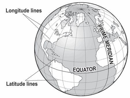
Also referred to as “meridians”, longitude lines merge at the North and South Poles. Because of the Earth’s spheroid shape, longitude (north/south) lines are farthest apart from each other at the Equator. When you see the zero degree longitude (0°), this meridian passes through Greenwich, England and is known as the “Prime Meridian.”
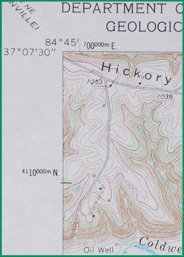
When used together to provide precise points, longitude and latitude numbers are divided into seconds (“) and minutes (‘). Each degree contains 60 minutes, with each minute containing 60 seconds. Segmentation of GPS map coordinates into tenths and hundredths offer even more precision when determining the best route to a specific location. An example of a coordinate would be one written as 40°50’25” S by 75°10’20″E. This would read as 40 degrees, 50 minutes and 25 seconds south (of the equator), and 75 degrees, ten minutes and 20 seconds east (of the Prime Meridian).
Geographic Coordinate System
A geographic coordinate system is capable of defining any position on Earth. The coordinates are often chosen such that one of the numbers represent vertical position, and two or three of the numbers represent horizontal position. A common choice of coordinates is latitude, longitude and elevation.
There are organizations around the world which continue to use historical prime meridians as a reference, however, the majority of systems use the Prime Meridian (longitude 0°).
A datum is a set of reference points on the Earth’s surface against which position measurements are made and (often) an associated model of the shape of the Earth. It is used as a convenient frame of reference when determining locations. When a datum is considered “local,” this means that the information regarding coordinates correlate to the surface of the Earth in that particular region of the world.
GPS map coordinates and equipment utilizes the WGS84 datum. It is the reference frame used by the U.S. Department of Defense (DoD) and is defined by the National Geospatial-Intelligence Agency. The WGS84 datum, which is almost identical to the NAD83 datum used in North America, is the only world referencing system in place today. WGS84 is the default standard datum for coordinates stored in recreational and commercial GPS units.
How to Get GPS Map Coordinates from Online Maps:
- Perform a search using the landmark or location on the Google Maps website by entering your query in the search bar.
- After you have entered this information, click “search maps” and you should immediately see the location highlighted on the map.
- The map may need centered at this point, especially if you want coordinates for an area neighboring the location for which you searched. To do this, right-click your mouse once you have place the cursor over the site on the map and choose “center map here” when the option list appears.
- Look to the right side of the page and examine the options. Click “link” from this list. This should provide you with a URL directing you to the coordinates for this location.
- Now find the GPS map coordinates in the link. They will be numbers found at the end of the link and resembling this style of linear coordinates: “35.705042” and “-66.133767”. Enter these coordinates into your GPS device to receive directions that will get you to this destination as quickly as possible.
Various online tools facilitate finding longitude and latitude of any place in the world. For example, if you go to our Cool Map Tools page, you can enter a location name and instantly find the coordinate for that location. When entering “Los Angeles, California” into the search box, you are not only given the information “N Latitude: 34 5 10.17240, W Longitude: 118 22 33.54362”, but also the decimal longitude/latitude: 34.086159 -118.375984. In addition to receiving GPS map coordinates, you also receive tools to calculate elevation by entering longitude and latitude as well as a tool that plots coordinates on a map.
Sources:
- http://www.wisebizz.info/gps/gps-coordinates.htm
- http://en.wikipedia.org/wiki/Geographic_coordinate_system
- http://www.maptools.com/UsingLatLon/
- http://www-istp.gsfc.nasa.gov/stargaze/Slatlong.htm
- http://publib.boulder.ibm.com/infocenter/db2luw/v8/index.jsp?topic=/com.ibm.db2.udb.doc/opt/csb3022a.htm
- http://www.maps-gps-info.com/cool-map-tools.html#LLB1
- http://webhelp.esri.com/arcgisdesktop/9.2/index.cfm?TopicName=about_geographic_coordinate_systems
Browse all the other GPS articles and features.