What are topographical, or topo maps? How do you read them? How do you make an informed buying decision? It’s all here!
The definition of topographic is: Graphic representation of the surface features of a region or place on a map, indicating their relative positions and elevations.
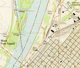
Topo maps are line-and-symbol representations of natural and selected manmade features of a part of the Earth’s surface plotted to a definite scale. A distinguishing characteristic is the depiction of the shape and elevation of the terrain by contour lines (see “How to Read Topo Maps” below).
The characteristics of the terrain, as determined by precise engineering surveys and field inspection, are recorded on the map in a convenient, readable form. They show the location and shape of mountains, valleys, and plains; the networks of streams and rivers and such man-made features as roads, railroads, buildings, dams, canals, mines and levees.
Formats
Topo maps are available in paper form or on CD ROM. They are available as books for an entire state. Learn more about topo maps in books. They are also available as separate sheets. The separate sheets, called quadrangles (or quads) are preferred for very detailed viewing because of the large scales available. Go here to find out about USGS quadrangles. In place of the quads, custom maps can be ordered. With custom maps you are not limited to a particular area or scale. You can buy one custom map to replace anywhere from 2 to 16 standard maps, saving you a lot of money. For more information on custom topos, click here.
The CD ROMs are versatile because you can use your computer to view any area seamlessly and print any area you wish. Digital technology has allowed us to use CD ROMs to perform a great number of useful and amazing tasks. If you want to know more before making a buying decision, check out reviews of topo maps on CD.
Online Topo Maps
The two best services for viewing and printing free online topo maps are MapTech and TopoZone. The advantage to MapTech is it shows coordinates wherever you move the cursor on the map. MapTech also displays nautical and aeronautical maps. The disadvantage is an occasional ad popping up on the map. The advantages to TopoZone are; 1) maps can be viewed and printed at three different sizes; and 2) viewing and print quality is slightly better than MapTech.
How to Read Topo Maps
History of Topo Maps
How Topo Maps are Made