With advancing technology, GPS car navigation (sometimes called “portable GPS”) is becoming more and more practical. Features like automatic routing, voice-guided navigation, and route re-calculating are more refined. Over the past few years, less expensive units have come on the market. Although the average price of GPS car navigation has dropped a little, the value has increased with more, and better, features. The technology we have today has made it easy for mobile devices manufacturers to add GPS functions to the mobile phones or the PDA’s they make. If you have a mobile phone that has a GPS feature you can find free GPS software for mobile devices here.
(Browse all the other GPS articles and features.)
1 – A Word About OEM Products
You’re not likely to choose a new vehicle based on its GPS system. But knowing a little about them may help you decide whether to fork over the cash for an after-market or an OEM product. OEM units are GPS car navigation devices that are available as factory-installed options on cars (OEM means original equipment manufacturer). They cost from $1000 to $2000 which means they’re likely to cost significantly more than after-market or stand-alone units, which run about $120 to more than $1500.
OEM and after-market units offer comparable features and performance. The decision whether to go OEM usually boils down to convenience, security, aesthetics, and cost. An OEM unit is more secure and because it’s built in, it looks nicer. Other than cost, the main drawback is that you can’t move it from vehicle to vehicle. One more point – find out how much it costs to update the maps and how difficult it is to do so. Some people have reported problems getting map updates.
2 – Physical Attributes
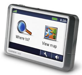
An average sized GPS car navigation unit is about 3.5″ high, 5″ wide, and 1″ to 2″ deep. The manufacturers try to compromise between small size for portability and larger size to accommodate an easy-to-see screen. They mount in your vehicle in a variety of ways.
Many use a suction cup mount attached to the windshield or dash. They can be screwed to the dash or console with a bracket. Some even have a beanbag type base that is held to the dash by friction. All methods work surprisingly well and your choice of mounting would be influenced by portability, aesthetics, and finding a position suitable for good satellite reception. Currently, (February, 2009) California and Minnesota prohibit using suction mounts on the windshield while driving.
3 – GPS Receiver
The receiver’s function is to provide your location by determining the latitude and longitude, and on some units, altitude. Position accuracy varies little from model to model and is normally within 20 feet if the GPS antenna (usually integral) has a clear view of the sky. Occasionally accuracy is not as good as within 20 feet if the receiver doesn’t have a lock on enough satellites. This might occur in situations of heavy tree cover or tall buildings. Although there may be times you lose a lock on all satellites, most of the time the unit will work fine.
Some GPS car navigation models have a feature called “dead reckoning.” This means that the unit will attempt to maintain routing directions in the event of loss of satellite lock. Dead reckoning works by using a compass or gyroscope. Because it’s tied in with your reverse lights and speedometer it must be permanently installed. The models with dead reckoning are considerably more expensive and unless you are doing a lot of big-city driving where tall buildings will block the signal, the extra cost usually is not justified.
4 – Data Input
Addresses and points of interest are input a couple of different ways. Some units use a four-way rocker control to move a cursor up/down/left/right on an alpha-numeric matrix to spell out the destination. On some more recent models you use your finger on a touch-screen. On some models (usually the PDA type) you use a stylus on the touch-screen. Each method has its advantages and disadvantages and the stylus method can be tricky. It comes down to dexterity, patience, and practice.
There is at least one model made that is voice-activated. The VCommand VCOM is 100% voice-interactive GPS car navigation and it has no display. It’s a great safety device since there is nothing tempting you to take your eyes off the road. It costs about $1000.
5 – Routing
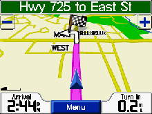
The primary function of an automobile GPS is, of course, to give driving directions. Almost all GPS car navigation models have a voice that gives you turn-by-turn directions. Although not always perfect, the routes calculated by these devices are pleasingly accurate. Where they sometimes fail or otherwise are confusing are situations of unconventional road or highway intersections. For instance, you may be instructed to turn left at an intersection where there are actually two streets from which to choose. Fortunately situations like this don’t happen often.
Most models do a fairly good job of calculating the best route. On many models you can program the unit to do such things as take the fastest route or the shortest route. Other similar features are the ability to have preferences to avoid certain roads or areas.
Most models automatically recalculate a new route whenever your route deviates from its planned route. This is handy for detours or perhaps if you think you know a shortcut.
There is one system being tested now (February, 2009) that ties the GPS receivers of 200 vehicles in one particular city into a network. The idea is that if a vehicle is travelling slower than normal, the system will instruct all other drivers to avoid that area due to likely traffic congestion.
6 – Maps
The GPS maps required for a car navigation system are very detailed. In addition to the need for highly accurate maps, the map database must store a lot of data about roads and highways. This information includes speed limits, names and road numbers of all streets, one way streets, expressway ramp details, among many other details.
Not even the most current maps are perfect. There will be a few errors in addresses, road names, road placement, and some roads may be missing. Most of the time, the maps are quite accurate. NavTech is one of the best map publishers. They are used in Garmin and Magellan, as well as some other brands.
Storing detailed map data necessary for navigating requires a lot of memory. The most common form of memory storage in GPS systems is a Secure Digital (SD) or Compact Flash (CF) card. These cards are available in many different capacities. The larger the capacity, the more expensive they are. Most current GPS receivers come with enough memory to cover an area ranging in size from a large city to several states. When travelling, it’s not unusual to need maps for more than one region, meaning that you need to buy more memory.
7 – Points of Interest (POIs)
POIs can be just about anything: restaurants, hotels, gas stations, parks, or ATMs. POIs stored in the database often number in the millions and sometimes include phone numbers. Since businesses sometimes change location or go out of business, some POIs will be wrong. Keeping your unit updated regularly will minimize the problems and, like the maps, the POIs will mostly be correct.
For more information, check out How to Choose a GPS.
Check Out My Product Reviews
I have reviewed the following GPS car navigation systems:
- GPS review Garmin iQue 3600
- GPS review Garmin iQue M5
- GPS review Garmin Quest
- GPS review Garmin StreetPilot 2610
- GPS review Garmin StreetPilot 2730
- GPS review Garmin StreetPilot c340
- GPS review Garmin StreetPilot i3
- GPS review Lowrance iWay 500c
- GPS review Magellan RoadMate 500
- GPS review Navman iCN 630
- GPS review TomTom Go
GPS car navigation reviews at Pocket GPS World.
Browse all the other GPS articles and features.