WAAS stands for Wide Area Augmentation System. Normally, unaided GPS is good for an accuracy of about 10 meters. WAAS provides an accuracy of 1.5 meters. WAAS was jointly developed by the Federal Aviation Administration (FAA) and the Department of Transportation (DOT) to provide precision approach capability for aircraft. The system was put into operation on July 10, 2003. WAAS is just one of several Space Based Augmentation Systems (SBAS) worldwide.
WAAS is similar to DGPS only it covers a much greater area – the entire continental U.S. and some of Alaska. While the system was developed for aviation, other areas benefit, too. It is used for mapping and surveying as well as providing greater accuracy for handheld and auto navigation receivers. For mapping and surveying purposes, accuracy is often less than one meter.
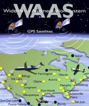
How WAAS works
There are a few things that cause GPS not to be perfectly accurate. The charged particles of the ionosphere, and water vapor of the troposphere slow the signal slightly. Multipath, ephemeris errors, and the atomic clocks on the satellites themselves can also contribute to the inaccuracies.
Throughout the continental U.S. are 25 “reference stations.” These are GPS receivers that are placed at points that have been very accurately surveyed. These reference stations receive the same GPS signals as the moving receivers. The difference is instead of using the signal’s travel time to calculate position, the reference stations use their known position to calculate timing. Because the reference stations know exactly where they are, they can figure out what the travel time of the signals should be. They then compare the calculated times with the actual times. The difference is an “error correction” factor.
The error information is sent to two master stations (one on the U.S. east coast, one on the west coast) which calculate correction algorithms and assess the integrity of the system. A correction message is uplinked to the two WAAS satellites via a ground uplink system.
The two satellites are in geostationary orbits. These satellites then transmit the correction information back down to the GPS user on the GPS frequency. The GPS receiver then decodes this information and applies it to its calculated position to significantly improve the accuracy.click the triangle to play
The benefits of WAAS to civil aviation will be considerable. WAAS improves the efficiency of aviation operations due to:
- Greater runway capacity
- Reduced aircraft separation which allows increased capacity in a given airspace
- More direct enroute flight paths
- New precision approach services
- Reduced and simplified equipment on board aircraft
- Substantial cost savings due to the elimination of maintaining older navigation aids
Europe has an equivalent of WAAS called EGNOS (European Geostationary Navigation Overlay Service). Japan is also developing a similar system called MSAS (Multi Functional Transport Satellites [MTSAT] Satellite – Based Augmentation System).